

Yarwood Ruins
THE TOWNSHIPS OR SUBDIVISIONS OF BURRA
and other settlement sites
Please click on the red dots which are all linked to photographs, maps and brief descriptions of the Townships.

This page has been compiled from information supplied by the Burra History Group.
The map is derived from the South Australian Government's Property Location Browser
Aberdeen

Detailed Survey map of Aberdeen
Courtesy: SA DPTI
Click here to enlarge

A later Survey map of Aberdeen
Courtesy: SA DPTI
Click here to enlarge
This is a subdivision of section 4 Hundred of Kooringa by Robert A.A. Morehead and Matthew Young in 1849. It reflects an attempt by the owners of the failed Bon Accord Mine to make some money from their holding. Presumably it takes its name from the Scottish city of Aberdeen which derives its name from its location near the mouth (aber) of the River Dee.
Except for a slight irregularity in the southeast corner, the plan was a simple grid, but in 1862 the main road to the north was cut through the northern portion of the town in a wide arc and more recently the road to Morgan has extended this disruption somewhat.
By and large the attempted sale of Aberdeen failed and by 1873 there were 10 houses, 2 hotels and 2 shops. All, but one of these were located along the main road. The development of this subdivision proceeded very slowly from the arrival of the railway in 1870 to the present time.
The 1875 petition for a Town Council claimed there were then 39 houses.

Aberdeen in the 1930s

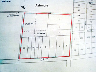
Detailed Survey map of Ashmore
Courtesy: SA DPTI
Click here to enlarge
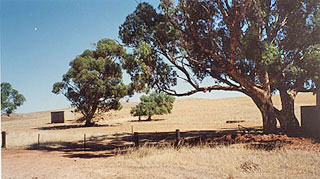
A subdivision of section 78, lot 2, of the Hundred of Kooringa in 1859 by Matthew Henry Furniss, accountant of the Burra Burra Mines. The rubble by the shed may be the remains of one of the only two houses known to have been erected on this subdivision. This photo was taken in February 2001.
Ashmore
This is a subdivision of part of section 78 of Hundred of Kooringa, adjacent to Westbury. It comprises only 14 allotments and has now reverted to farmland.
The available plan of it is hard to read, but appears to bear the date 1859. In 1873 there were two poor quality houses on it.
Manning’s Place Names of South Australia does not suggest an origin for the name, but there is an Ashmore in Dorset.

Burra Burra Mine

Detailed map of Burra
Click here to enlarge
Throughout the period of the mine’s operation there were a number of houses on the mine site as shown on the map on the right. Some remained occupied long after the mine’s closure.
Though the mine was always called the Burra Burra Mine, Burra as the name for the town was only official from 19 September 1940. The origin of the name is disputed. The original pastoralist, James Stein, had Indian coolies working for him as shepherds and Burra Burra was said to come from Hindustani for ‘great great’ in reference to the creek that ran through the property. Stein came from Scotland where the name also occurs in the Shetland Islands, derived from Old Norman borgarfiord for a fortified hill. In other parts of Australia burra occurs in a number of Aboriginal languages meaning people or tribe. The Hindustani origin seems to be the one most favoured.

Detailed map of Burra Burra Mine
Click here to enlarge


Detailed Survey map of Charleston
Courtesy: SA DPTI
Click here to enlarge

Detailed Survey map of Charleston SW Corner
Courtesy: SA DPTI
Click here to enlarge
Charleston
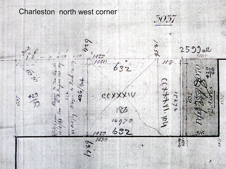
A part of section 2070, Hundred of Kooringa was named Charleston by Johann C.C. Meyer who subdivided it in 1859, having acquired the section by land grant in 1853. We have not been able to find a complete map of the subdivision, but there is a partial one from 1882 when the area was brought under the Real Property Act. This shows a truncated grid pattern of streets which were presumably more extensive originally. Only five allotments are marked: 1-4 and 62. In the 1873 assessment there were 2 houses here.
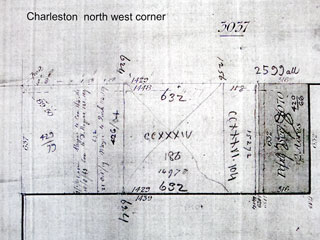
Detailed Survey map of Charleston NW Corner
Courtesy: SA DPTI
Click here to enlarge


Copperhouse


This village was laid out on part of section 52 Hundred of Kooringa, contiguous to Lostwithiel, by William Oliver, licensed victualler of Redruth, in 1858.
The name comes from Copperhouse in Cornwall.
It was a simple plan with one street of houses, Alankeen St, extending east-west from the north-south government road. There were 30 blocks and a reserve.
In 1873 there were 14 houses, one of which was probably the former Commercial Inn, and a Primitive Methodist Church.
There was a school which may have utilised the church building as after 1900 the Education Department bought it and modified it for that purpose.
The town slowly declined from the closure of the mine in 1877 to the middle of the 20th Century.
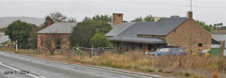
Today two houses remain (left) and the school building, (below).


Graham

This was laid out in 1875 on part of section 1 Hundred of Kooringa by the SA Mining Association. It was named after J.B. Graham, a substantial shareholder in the Burra Burra Mine.
It is bounded by Aberdeen to the north and the Burra Creek to the east. The closure of the mine in 1877 meant that it failed to develop. When it was established the Smelters’ Home Hotel already occupied lot 3 and the Mine Hospital was on lot 6. Lot 21 was occupied by the house of the mine accountant Mr Furniss. Roach’s Flour Mill occupied lot 2. New building had to wait till 1924 when the town’s powerhouse was built on lots 8 & 9.
The 1875 petition for a Town Council claimed there were then 5 buildings.
In 1905 E.A. West laid out a new subdivision on the eastern side of the Burra Creek adjacent to Graham. It comprised 75 allotments. This is also referred to as Graham in Council business, but it too failed to attract new housing until the 1920s. Since then it has grown substantially with new housing since 1960 as well.


Hampton

Detailed map of Hampton
Courtesy: SA DPTI.
Google Earth view of Hampton

Detailed map of Hampton
Courtesy: SA DPTI. Click here to enlarge
Thomas William Powell (1806-1891) made a subdivision of part of sections 480 and 2071 Hundred of Kooringa in 1857.
In 1833 he married Rebecca A. Wixen who was born in Hampton in Middlesex in 1810. No doubt the town is named after her birthplace. The Old English ham-tun means ‘home town’.
At one time the town had at least 30 houses, but it was on the outskirts of Burra and beyond the reticulated water supply. It gradually dwindled into a ghost town from the 1960s.
It is now a heritage area owned by the Regional Council of Goyder and is a significant archaeological site.
Allotments are numbered to 55, but despite there being several maps lots 41 & 42 have not been located; there being a large central area where lot boundaries are not known.
The southeast corner is the location for one of Burra’s more important quarries for road and building stone.
The 1873 assessment indicates 20 houses.
The 1875 petition for a Town Council claimed there were then 24. [There is evidence that houses were sometimes divided, so there may not have been more buildings.]

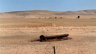
Ruins of Hampton in 2004

Harrow Hill

Detailed Survey map of Harrow Hill
Courtesy: SA DPTI. Click here to enlarge
Thomas Powell (1806-1891) subdivided section 83 Hundred of Kooringa in 1860.
He migrated from Middlesex in 1849 and named this after Harrow-on-the-Hill in that county. The name derives from hearg-weoh meaning ‘heathen temple’ or ‘shrine of an idol’.
There were only 10 blocks of quite large size: ranging from about 170m x 80m to almost 300m x 120m. There seems to be no evidence that settlement ever occurred and by 1952 the whole area had been claimed by right of possession and was farmland.

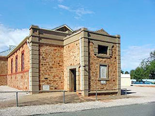
Redruth Gaol & Police Paddock
The police paddock was used to accommodate the horses for the mounted constables stationed at Redruth. In 1887 the 20 acres south west corner were reserved for police use and the rest was divided into 5 acre allotments for sale as working men’s blocks, as can be seen on the map. It was intended that produce from them would supplement the income of workers.
Built in 1856 Redruth Gaol was the first gaol built outside of metropolitan Adelaide at a time when Burra was the largest country town in South Australia.
The original building was constructed by Watson and Morris at a cost of about £3200. Changes were made to the building in 1863 and 1877. The gaol provided accommodation for the gaolkeeper, turnkey and 30 prisoners, male and female.
Following the closure of the gaol in 1894, the Woollacott family lived there until 1897. Later in the same year the building became the Redruth Girls' Reformatory and served as such until 1922.
The Todd family made it their home from 1943-57
In 1979, the building was used in the filming of Breaker Morant.
The site has been in the care of the National Trust of South Australia since 1977, and a considerable amount of conservation work has been undertaken since that time.
When the gaol closed in 1897, the prisoners were transferred to Gladstone Gaol.
The gaol was renovated and opened as a Girls’ Reformatory in 1897 and closed in 1922.

Helston
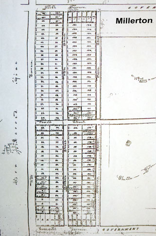
The London Mining Journal 10 March 1858 has an item about the Bon Accord Mine and notes that ‘for sale in allotments, the township of Helston, adjoining the above mine, the Church and Wesleyan Glebes and the Government Reserve. This description doesn’t accord very well with reality and the area best matching the description and lying between the Glebes and the Bon Accord property is occupied by Millerton. There are no plans available to clarify the matter.
There is a Helston in Cornwall and the name may derive from either the Cornish hellas meaning ‘a marsh’ or from Old English henlis-tun meaning ‘old court town’.
Kooringa

Detailed Survey map of Kooringa
Courtesy: SA DPTI.
Click here to enlarge
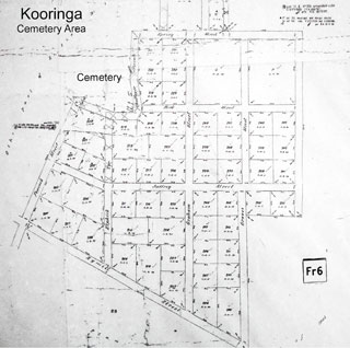
Detailed Survey map of cemetery Area
Courtesy: SA DPTI.
Click here to enlarge

Detailed Survey map of Dugouts Area
Courtesy: SA DPTI. Click here to enlarge

Detailed Survey map of Market Square Area
Courtesy: SA DPTI. Click here to enlarge

Detailed Survey map of Western Entrance
Courtesy: SA DPTI. Click here to enlarge
Manning cites the Register 1 April 1846, p.2.
‘The directors of the SA Mining Association, who had determined on giving the name ‘Truro’ to a township at the Burra Burra Mine, have since resolved to adopt the very euphonious name of a locality and the town of ‘Coolinga’ is now duly laid out. Mr Crawford of the Hindmarsh Brewery has contracted to erect an inn there on a scale of magnitude not yet attempted in the colony . . . and it is said he will attach a brewery to the new establishment.’
The evidence of the hotel and brewery make it clear that ‘Coolinga’ is in fact a mistake for Kooringa.
The main town adjacent to the Burra Burra Mine was laid out entirely on the SA Mining Association’s property in 1846. The Association did not grant freehold title until the 1870s and this meant that the housing constructed tended to be of poor quality and it also encouraged the proliferation of other subdivisions adjacent to the northern and western boundaries of the company’s property.
The town plan is essentially a grid pattern for the most part. The oldest area lies west of the Burra Creek, but the adjacent area east of the creek is almost as old with substantial expansion to the south east by the 1870s and a small modern extension in the north east corner dating essentially from the 1970s.
The town was built almost exclusively of stone cottages, though initially the miners preferred to live in dugouts in the banks of Burra Creek. These were cooler in summer and warmer in winter as well as being rent-free. The disadvantage came from rather frequent floods and after two disastrous floods in 1851 the company refused to hire anyone living in the creek bank. At its peak at least 1,500 had so lived. It became the civic and commercial centre for all the Burra towns with the commercial core around the roughly triangular shape of Market Square.
The name appears to be derived from the Aboriginal kuri-ngga, meaning ‘in the circle’. The kuri was ‘a dance among the northern tribes, at which the men, ornamented with white stripes or dots on the face and chest, and green leaves around their knees, first form a circle, then stamp with their feet alternately on the ground, while the women sit down and sing.’
Rodney Cockburn, What’s in a Name? Nomenclature of South Australia, 1908, gave the meaning as ‘locality of sheoak’.
The mining company constructed many cottages for its employees. Some of these formed long terraces and the most significant of these, Paxton Square, remain as tourist accommodation. The town is characterised by its many bluestone houses. Though many of the miners’ cottages have been demolished over time, a significant number remain and more substantial stone houses built after 1870 have added to the character of the town. The public buildings, especially the churches, Public School and the Institute (later the Town Hall) are impressive.
In 1873 the assessment suggested there were about 365 houses.
Kooringa, 1872

Kooringa today


Llwchwr

Detailed Survey map of Llwchwr
Courtesy: SA DPTI. Click here to enlarge
The English and Australian Copper Co. Ltd gave this Welsh name to a subdivision of section 2067 Hundred of Kooringa, c. 1851. The name itself means ‘a lake’, the English translation being ‘Loughour’.
There were 44 lots and in 1855 the company brought out Welsh migrants to work in the smelter and created this village. Whether the Welsh colonists actually lived here seems doubtful. There were a number of cottages closer to the smelting works on the company’s lease and by 1873 there were only 5 houses there of which three were occupied by German migrants.
The 1875 petition for a Town Council claimed there were then 6 houses.
Locally the spelling is sometimes Llwchyr.

Lostwithiel

Detailed Survey map of Lostwithiel
Courtesy: SA DPTI. Click here to enlarge

Ruins of the Race Course Hotel on Lot 23, on the corner of the main road and Elizabeth St in January 2001

Other ruins of the Race Course Hotel
John Stevens Reed (1806-1872) subdivided this portion of section 52 Hundred of Kooringa, contiguous with Copperhouse, c. 1858. He was a licensed victualler of Aberdeen and named it after his birthplace in Cornwall. The name means ‘place in the woods’ which is rather ironic considering Burra’s surrounding were notorious for their lack of trees.
Like Copperhouse, it has one east-west street, Elizabeth St, running off the north-south government road.
It shared the initial prosperity of Copperhouse and also its ultimate fate.
There were 23 allotments and in the 1873 assessment it had 12 houses, one of which was also a shop, and one hotel.
Today no building remains, but heaps of stones mark some of the house sites.

This subdivision on section 2073 in the Hundred of Kooringa was made by Henry Miller in 1858. It was then described as being bounded ‘on the west by the town of Aberdeen, on the east by the church Glebe and the Wesleyan Glebe and the north by the new townships of Nelson and Yardley. . . . in fact an extension of Redruth . . . the proposed new church and the court house are within a few hundred yards of the township.’
Nelson actually lies a little to the east, while Yardley cannot now be identified at all.
It was advertised for sale in the Register 22 July 1858 and 2 August 1858.
It seems to have been a slightly better sale than others of this period and somewhat more than 25% of blocks seem to have sold.
The 1873 assessment lists 5 houses and while there may have been gains and losses the result has been little difference over the years.
The 1875 petition for a Town Council claimed there were then 6 houses.

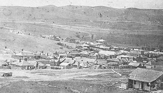
Aberdeen in foreground and Millerton in background


Detailed Survey map of Nelson
Courtesy: SA DPTI. Click here to enlarge
Nelson
Anthony Forster and Samuel Nelson made this subdivision of section 3033, Hundred of Kooringa, with the plan saying it was laid out 9 July 1858. It was offered for sale 30 July 1858 and the Register 6 August 1858 says all but 5 allotments were sold.
The plan shows a strangely shaped town sprawling in a long crescent along the western boundary of sections 3033 and 3039. The southern part is only a couple of allotments deep, but in the north it widens to a small network of streets at a variety of angles. Despite the sales report there is little suggestion that many houses were ever erected. Early assessments show list several houses at Nelson, but as no allotment numbers are given some may have been on adjacent farmland.
The 1873 assessment lists 5 houses at Nelson and one of them has allotment numbers. Ruins today confirm at least three within the town limits. Today it is farmland.
The 1875 petition for a Town Council claimed there were then 3.

New Aberdeen
This subdivision of part section 4 Hundred of Kooringa appears to have been another attempt to get some income from the Bon Accord property. It was almost certainly inspired by the arrival of the railway in 1870 and the lodged plan is dated 1872.
The plan is unlike most others in the area by not being a simple grid. The street alignments are complicated by the pre-existing main road running north, the railway reserve and the creeks, though the latter are ignored for the main part. The original plan was later interrupted by the extension of the railway to Hallett which opened on 10 May 1878. There was always however, a railway reserve swinging in an arc across the centre of the area. This clearly allowed for the extension of the railway to the mine site and/or the smelts and/or Kooringa. This would have meant cutting across Aberdeen for which no provision had been made, but given the lack of building this would not have been too difficult. In any case no such extension was ever made.
Despite the arrival of the railway there seems to have been no rush to buy and develop this part of the town. By the time of the assessment in 1873 only 18 of 144 allotments seem to have been sold and all are said to be vacant land. The only buildings listed are those of the old Bon Accord Mine. Like Aberdeen, growth came slowly in the later 19th century and has continued.

Detailed Survey map of New Aberdeen
Courtesy: SA DPTI. Click here to enlarge
Nevertheless the railway was certainly significant and did soon cause several major developments in New Aberdeen. A flourmill, a new hotel, a large bulk store for S. Drew & Co., importers, extensive stockyards and the steam sawmill etc. of Sara & Dunstan were all a response to the location of the railway.

Saleyards

Princess Town / Prince's Town

Detailed Survey map of Princess Town
This is a somewhat mysterious settlement of miners etc. on the southwestern fringes of Kooringa. There are quite a lot of references to people living there, but it does not appear to be named on any map and the Lands Titles Office has no plan of the town. Early council assessments and one or two references in the local paper suggest it occupied section 2264 in the Hundred of Kooringa, but there is a nineteenth century Hundred map showing a pattern of streets on the adjacent section 2267.
In the absence of more explicit information the section 2267 evidence seems most convincing, while anyone living on part of 2264 would most likely have also used the name. The town is on the slopes of Princess Town Hill.
There is a Princetown in Devon which might conceivably have some connection.
Redruth

Detailed Survey map of Redruth
Courtesy: SA DPTI. Click here to enlarge

Google Aerial map of Redruth
Courtesy: SA DPTI. Click here to enlarge
The town was surveyed in 1849 around a reserve which housed a police station built in 1847. There were 120 allotments. It is named after its Cornish counterpart. The origin of the name is obscure. It may come from re-druith meaning ‘the Druid’s Town’, or rhe-druth meaning ‘swift stream of the druids, or ridruth, meaning ‘red ford’.
At its sale the representatives of the SA Mining Association forced up prices to an unrealistic level and it therefore failed to get the big head start on its rivals that its early date would suggest, nevertheless it was the centre for government activity as a result of the location of the court and police station. It had three churches and from 1856 the Redruth Gaol was on its northern edge. Despite being available for freehold many of the cottages built were little different from those on the Kooringa leasehold property. The present houses are a mixture of buildings from the 1850s to the present day with some very nice examples of early miners’ cottages among them.
The street pattern is basically a grid but a diagonal road runs from the police station to the gaol site. Another curving road in the north of the plan has disappeared from the map of today’s town.
At the 1873 assessment there were 64 houses with several shops and a hotel.
The 1875 petition for a Town Council claimed there were then 63 houses.

Redruth and Aberdeen


Redruth Wesleyan Glebe
This 20 acre block was granted by the government to the Wesleyan (Methodist) Church in 1850.
Redruth Anglican Glebe
This 20 acre block was granted by the government to the Anglican Church in 1850.
The grant explains why the original Anglican rectory was erected at Burra North so far away from both the original St Mary’s church on Limestone Hill and the present church on Market Street, Kooringa. In 1920 a new rectory was erected in Bridge Terrace.

Detailed Survey map of Roach Town
Roach Town
In 1858 Isaac Killicoat (1808-1886) gave this name to a subdivision of section 2071 Hundred of Kooringa. While Roach is a common name in the area, it is probably named after Henry Roach, Chief Captain of the Burra Burra Mine from 1847-1868. Mr Killicoat arrived in SA in the "Abberton" in 1854 to take up the position of manager of the smelter operated by the English & Australian Copper Co. at Burra.
The only available plans for the town come from deeds surrendered when the land came under the Real Property Act. There were allotments either side of a single street, called Killicoat St. The size of the known allotments suggests there might have been as many as 32, but this is conjecture based on very incomplete sketches. Early assessments from the council suggest that at least lots 1,3,5,7,11, 13, 15, 17 & 19 were bought.
The 1873 assessment lists 1 house at Roach Town.
The 1875 petition for a Town Council also claimed there was 1.
St Austell
The 1873 assessment gives this name for the location of one house on part section 2070.
There is no known subdivision for this section and the reference could be a mistake for the name of the house.
St Austell is a town in Cornwall.
St Blazey

Detailed Survey map of St Blazey
Courtesy: SA DPTI. Click here to enlarge

January 2001 view of the paddock where Saint Blazey was surveyed
About 1859 Richard Goldsworthy (c. 1806-1866), an innkeeper of Copperhouse made this subdivision of section 73, Hundred of Kooringa.
There is a town of the same name in Cornwall.
We know of no evidence for any building on this site in the past and it is presently farmland.

Spring Bank

In this March 2001 photograph the site of the chapel can be identified from the remaining stones scattered here and the slight depression with a slightly greener tinge in the centre of the photo
This locality is a valley and farming community along a valley that runs south from Burra a little to the west, roughly in line with Copperhouse etc.
The only services in the area were a Primitive Methodist Chapel (Section 2222) and some tennis courts.
The name is used in England, but whether this is the origin is unknown.
Swansea Vale
(extent uncertain)
This is not listed in Manning’s 'Place Names of South Australia', but makes regular appearances in the early assessment books for the Corporation of Burra. It also appears occasionally in early local newspapers. The ford across the Burra Creek leading from the Burra Burra Mine to the Smelting Works, opposite the Mine Stores, is referred to as the Swansea Vale Ford. Several houses have this address and they have neither lot numbers nor a street address. The logical conclusion would seem to be that they were situated on the English & Australian Copper Co.’s lease, no doubt named after Swansea in Wales and adding ‘Vale’ because a tributary to the Burra Creek entered the property in the northeast corner and ended near the Mine Bridge.
[In By Gad to Plough: a History of the Sandow Family in Australia’ there is a statement that the English & Australian Copper Co. bought section 43 in the Hundred of Kooringa which they subdivided as Swansea Vale. But section 43 is a long way out of Burra and well beyond the boundary of the Town Council which clearly used the name to apply to part of its domain.]
Victoria Place

(exact sites & location uncertain)
Like Swansea Vale, this does not seem to have been a subdivision, but as a locality it appears in the early assessment books and is referred to sometimes in the local paper.
From that source it is clear that it applied to the last group of houses as you travel east beyond Redruth along the road to the east. (Well before you reach the junction with the road from Kooringa.) It is a name which was more likely to appeal to people living there thanH the alternative of Snake Gully by which the area is now more generally known. In 1901 three houses were given this address. They are still there.
Westbury

Detailed Survey map of Westbury
Courtesy: SA DPTI. Click here to enlarge
This paddock gives a general view of Westbury in January 2001
George Vickery made a subdivision of section 53 Hundred of Kooringa in 1859. On 13 March 1860 he advertised it in the Register as ‘ . . . about one mile from the Burra Burra and Bon Accord Mines, bounded in the south by a direct road to Clare, Riverton, Mintaro and Kapunda, on the north by that to Mt Remarkable. The Great Northern Railway is planned to run close to the south-east boundary.’
It is contiguous to Copperhouse and Lostwithiel and is a common placename in England meaning ‘western fort’.
It is now farmland. A few blocks were sold, but probably only about 17 or so. By 1873 there was one house on lots 230-231 and a Wesleyan Church on 232. These were almost adjacent to Copperhouse and after Methodist union in 1900 the Westbury Church became the Methodist Church, allowing the Copperhouse Primitive Methodist Church to be taken over by the school. It was as often referred to as the Copperhouse Church as the Westbury Church. Neither it nor the house remain.

Williamstown

Detailed Survey map of Williamstown
Courtesy: SA DPTI. Click here to enlarge
Section 80 of Hundred of Kooringa was subdivided about 1858 by William Oliver. It lies directly west of Copperhouse and is contiguous to it.
It is presently all farmland and there is no suggestion that it ever had housing on it.
In 1873 the council assessment suggests that 14 allotments of 106 had been bought.

Yardley
It is not at all clear if Yardley really existed. The only reference seems to be in the advertising for the sale of Millerton which was described as being bounded ‘on the west by the town of Aberdeen, on the east by the church Glebe and the Wesleyan Glebe and the north by the new townships of Nelson and Yardley.
The name appears in several places in England, for instance on the eastern side of Birmingham.
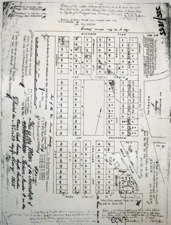
Yarwood

Detailed Survey map of Yarwood
Courtesy: SA DPTI. Click here to enlarge
Anthony Forster and Samuel Nelson, having subdivided Nelson on the northern outskirts of Burra, also offered a subdivision of part of sections 2249 and 2250 Hundred of Kooringa, some way to the south.
[The sections have subsequently been renumbered 174 & 175.]
It was offered for sale on 30 July 1858 and the Register 6 August 1858 reports it as being successfully auctioned. By the 1873 assessment there were 2 houses. It is presently all farmland with ruins apparently in the vicinity of blocks 13-14.

Towns and other places in the District
Within an approximate radius of 25 kilometres
Courtesy: SA DPTI. Click/tap all dots for the names of the places
Red dots will show information, maps and images of the place
THE TOWNSHIPS OR SUBDIVISIONS OF BURRA
and other settlement sites - position unidentified
Courtesy: SA DPTI. Click/tap for information

This page has been compiled from information supplied by the Burra History Group.
The map is derived from the South Australian Government's Property Location Browser
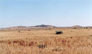
Apoinga
Apoinga lies almost due east of the southern tip of the lagoon, though there are also historic workings south of there.
It derives its name either from the Aboriginal word for ‘place where there is water’ or from ‘Appinga’, the name for the original tribe of the locality. It was some 6 km east of Black Springs and was the site of the first smelter in the north. Burra copper ore was smelted there first in January 1849 and by 1851 there were four furnaces and a population of about 100. The smelter, village and hotel were on section 1594 Hundred of Stanley and were created by Charles Mounsey Penny. Today nothing remains.
St Paul’s Lutheran Church, Cemetery and School

Site of the Baldina Lutheran Church of St Paul:1879-1913. The building was apparently of pisé construction.
Grave of C. W. Albert Mann
Born 21 May 1877
Died 23 May 1898
Baldina Cemetery.
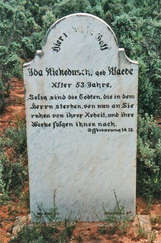
Grave of Ida Kiekebusch, nee Klaebe. Aged 53
Baldina Cemetery.

Baldina Lutheran Cemetery
Baldina Hotel

Baldina Hotel

Site of William Midwinter's Baldina Hotel, 1883 - May 1887, when it was destroyed by fire. The white stones on the ridge to the left mark the site.
Baldina Post Office
Baldina Ford
Baldina Ford, early 1900s

A December 2000 photo of the ford across Baldina Creek on the Eastern Road. When built this was at least 3 metres above the level of the creek.
Burra Record 25 Jan. 1884, page 3
The Baldina Ford, recently constructed by the Midland Road Board was opened to light traffic on Tuesday by E.C. Lockyer JP. Captain Killicoat, the surveyor and a few others attended. The work is first class.
Baldina Methodist Church

Baldina Wesleyan Church: Iron building in 1876, stone 1900 on Section 70c, and its ruins

Baldina Methodist Church “Stone Jug Church”

Cockburn says the name is an Aboriginal word referring to the springs in the creek
The Baldina Run, east of Burra, was established by Henry Ayers in 1851 and the Hundred of Baldina was proclaimed on 30 December 1875.
There was no town of Baldina but in the last quarter of the 19th century the locality around the point where the road to Robertstown parts from the road to Morgan was known as Baldina.
The post office was on section 42W. In fairly close proximity could be found the Baldina Wesleyan Church, the so-called "Tin Pot Church" in corrugated iron which was replaced by the "Stone Jug Church" in 1900 but would seem to have stopped being used by the 1920s and was demolished by the 1930s. Also nearby was the Baldina School (1885-1929) and William Midwinter’s Baldina Hotel.
Today none of these remain and modern usage of the name is more normally associated with the station, creek and ford to the east of Burra.
Portion of Hundred of Baldina
Baldina was the name of the Hundred. There was no town of Baldina but in the last quarter of the 19th century various services in the Hundred were given its name. For example Baldina Wesleyan Church, Baldina School, Baldina Hotel, Baldina Post Office.

Mintaro

Merilden Station 2016
The town was founded in 1854 by Joseph and Henry Gilbert on land purchased by Henry Gilbert in July 1849.
Originally, and for several years, Mintaro was a busy watering stop for throngs of bullock teams travelling the Gulf Road between the copper mining town of Burra and Port Wakefield, transporting copper and coal for the Patent Copper Company.
Note. The Mintaro railway station is some kilometers away and was renamed Merilden in 1917.
Baldry

Ruins of former Baldry Post Office and residence of Steward McWaters and family, built early 1800s. Section 166 Hundreds of Ayers.
Dr William J. Browne subdivided section 454 in the Hundred of Ayers, 19 km west of Burra, in 1875
He intended that it would supply accommodation for travellers, teamsters and those in charge of stock. It never developed as a town, though it was the site for the Booborowie Eating House and the original Booborowie Dictrict Council Chamber.
A post office with this name was opened in 1877 on section 442, 13 km west of Burra, but the name had to be changed to Leighton in 1888. Only a few ruins mark the site today.
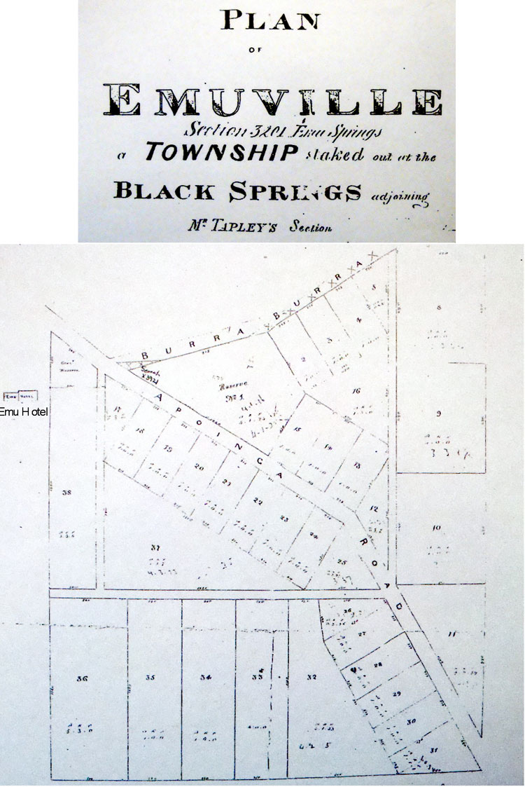
Emuville Hotel and The Spring


This name was given to a subdivision of section 3200 about 27 km south of Burra. It is at almost the same site as the Emuville subdivision.
The Emu Hotel which was near the springs themselves was opened in 1846 by Daniel Cudmore. In Colonists, Copper and Corn, edited by E.M. Yelland, 1970, Chapter 21 is devoted to Black Springs and it is there said they were discovered when the country was black after a bush fire, hence the name. This describes the two subdivisions and says their success would depend on the fortunes of the Karkulto Mine some 4km to the north. The mine was not a success and there is nothing at the site of the Black Springs now to suggest any town was there.
The settlement now known as Black Springs is actually a couple of kilometres southwest and was originally known as Glendore.

The spring at Black Springs
The Black Springs to Robertstown road at the point where it runs through the Emuville site
Booborowie
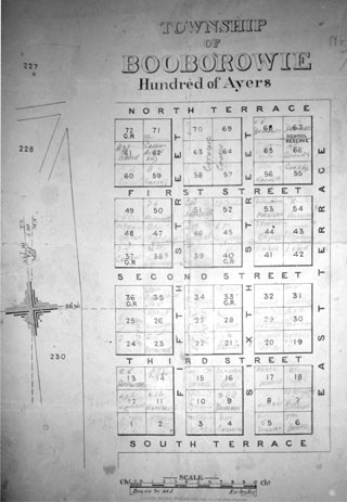
Survey Map of Booborowie
Courtesy: SA DPTI. Click here to enlarge
The name, Booborowie, derives from an Aboriginal word meaning ‘round waterhole’.
In 1843 Dr. William James Browne and his brother Dr. John Harris Browne took up the Booborowie run. In 1851 they purchased a crown lease of 153 square miles and in 1853 the brothers purchased 46,978 acres of the lease.
The Browne Bros. established a merino stud and had shorthorn cattle. They went on to purchase properties on the Adelaide Plains, at Mt. Gambier, the Flinders Ranges, Eyre Peninsula, and were instrumental in establishing Katherine in the Northern Territory. This led to a large sheep and cattle drive, under the supervision of Alfred Giles, to leave South Australia in 1878.
The northern portion of the station was sold to Henry Dutton and George Melrose in 1897. The remainder of the station was sold in 1910 and 1912 for closer settlement.
The Booborowie Township was proclaimed on 29th March 1877.
The Booborowie Valley is not only prime wool, sheep and cattle country, but is also a rich cereal crop and lucerne growing area.
The township supports many local businesses and trades people in the building industry that service the local area and mid north region.
Though there is an old core, the town experienced considerable growth in the mid-twentieth century resulting in a mixture of houses of different ages. The shopping facilities, as in all such small centres have declined greatly in the last half century.

Clonmel
In the Adelaide paper the Register, 2 August 1858 we read:
‘The township of Warrapoota was offered for sale at the Burra Hotel on Thursday in blocks of one, two, three and five acres, but there were no purchasers. It was again offered on Saturday with the like result. This is rather disheartening to those who are at present offering their land for sale in this manner, there being a considerable quantity in the market at present, viz. Millerton, Clonmel, Copperhouse, Hampton, Roachtown, Nelson, Yarwood and Warrapoota, besides Redruth Aberdeen and Kooringa.’
Absolutely no other information is available about this subdivision.
Davies

Former Methodist Sunday School building, now used as a holiday home
See Hanson.
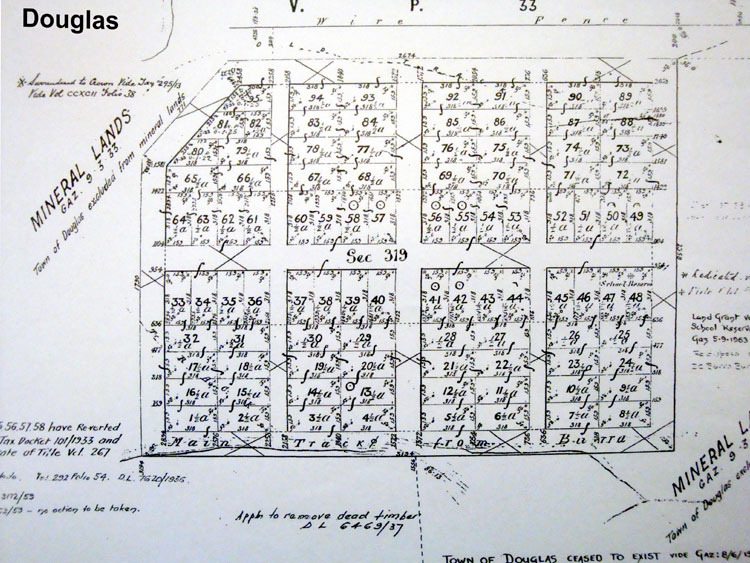
Douglas

Detailed Survey map of Douglas
Courtesy: SA DPTI. Click here to enlarge
This paddock is in the centre of Douglas in January 2001.
The site of Douglas lies 2 km west of the Baldina Creek ford on the northern side of the Eastern Road from Burra. Today there is no indication that there was ever a building of any sort on what is now pastoral country. The town, in the Hundred of Baldina, was proclaimed on 17 May 1877 and offered for sale 28 June 1877. Unsold lots were again offered in 1878. The town was possibly named after Captain Bloomfield Douglas RN, who did mapping and marine surveying in SA.
In 1877 a school reserve was created which was resumed in 1963. It was never used. Many blocks in the town were sold, but there is little to suggest houses were built. All allotments were cancelled and roads closed in 1959 and the town officially ceased to exist, vide SA Government Gazette 8 June 1981.
The only precise reference to a building in the town that I have found is in the Burra Record of 1 December 1885 when there is a report of an inquest into the death of a man found hanged in a hut in the township of Douglas on the previous Sunday. There was a Primitive Methodist Church at Douglas, but it was some distance away from the town site well to the east of the Baldina Creek ford and near the Thistlebeds homestead.
Douglas Church

The disturbed patch in the foreground marks the site of Douglas Primitive Methodist Church
The foundations of the Douglas Primitive Methodist Church.
To the left is the Burra-Redbanks road.
The Primitive Methodist Chapel at Douglas was opened on Sunday 23 July 1882. After Methodist Union in 1900 it continued as a Methodist Church but was advertised for sale in 1924.
Between 1889 and 1908 it also served as the Thistlebeds School.
Emuville

The Emu Inn was adjacent to Emuville allotments and the mound just beyond the tree in the foreground is probably its remains. The springs are immediately to the left. Photo taken January 2001
This was a potential town staked out by Edmund Bowman about 1860 as a subdivision of section 3201 Hundred of Stanley just east of the ‘Emu Springs Water Reserve’. The allotments lay along the Burra-Apoinga Road.
It probably never took off as a settlement, though the ruins of the Emu Hotel are on the site.
Adjacent to it today can still be seen the ‘Black Springs’ with the spring in a small stone enclosure and the old wooden water trough still in place.
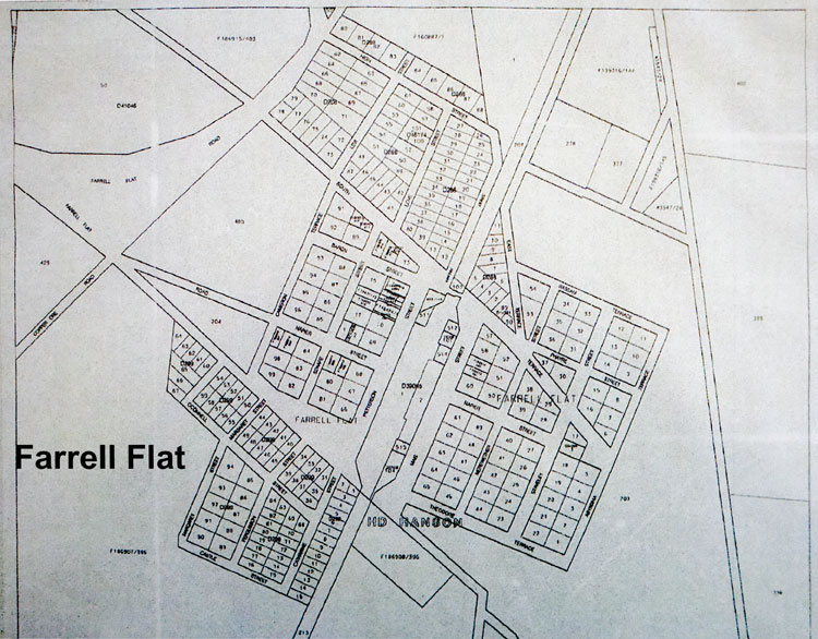
Farrell Flat

Detailed Survey map of Farrell Flat
Courtesy: SA DPTI. Click here to enlarge

Detailed Survey map of Farrell Flat
Courtesy: SA DPTI. Click here to enlarge

Farrell Flat in the 1950s

Farrell Flat railway station in the 1950s
The town of this name was surveyed as Hanson in 1870 and did not officially become Farrell Flat until 19 September 1940.
The name Farrell Flat, or more correctly Farrell’s Flat at that time, had been in use almost from the start though as that was the name of the railway station.
Official usage of Hanson, as for example for the school prevailed at least until about 1900.
It is sometimes a bit tricky to separate Hanson meaning Farrell Flat from Hanson meaning Davies/Daviestown in the early period.
The name is said by Cockburn to come from Rev. Dean Farrell, the second Colonial Chaplain.
H.C. Talbot says it is named for James Farrell, a shepherd employed by Joseph Gilbert of Mt Bryan. A pastoral lease survey of 1851 shows Farrell’s Creek on a property where the township now lies and this favours the Talbot version. Rev. Farrell did travel widely and was a popular visitor, so the doubt remains.
The town was a busy rail centre for wheat and quite a significant, but small service centre for farmers with a hotel, shops, churches, an Institute and sporting facilities.
As would be expected, its distance from Clare of only 19 km has meant that in more recent time shops there have taken over from local shops and the town is now mostly a group of houses without many services remaining.
Farrell Flat Hall - April 2005

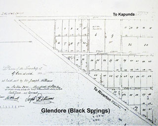
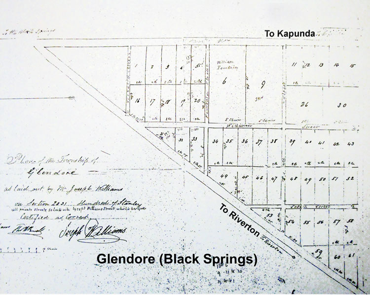
Black Springs/Glendore

In 1860 Joseph Williams subdivided section 2031 of Hundred of Stanley and in the 1870s it was described as being ‘one mile south of Black Springs and consists of a few scattered houses, a store, a chapel and a scattered population of about 70 persons’. It acquired two churches and a school in time, but now but now only one church building remains and a few houses. At some undetermined time the name Glendore dropped out of use and that of Black Springs was transferred to it. But what the official version of that is I don’t know.
Gum Creek School

Second Gum Creek School
The first Gum Creek school operated from 1898 to 1918 and shared the building with the Anglican Church.
The Second Gum Creek School operated form 1898 to 1957. The students were then transferred to Leighton Rural School.
The name comes from Gum Creek Estate on sections 553-583, 586-7 & 590-98 in the Hundred of Hanson.
John James Duncan purchased this from the estate of Walter Watson Hughes in 1888.
A post office on section 121 opened in 1925.
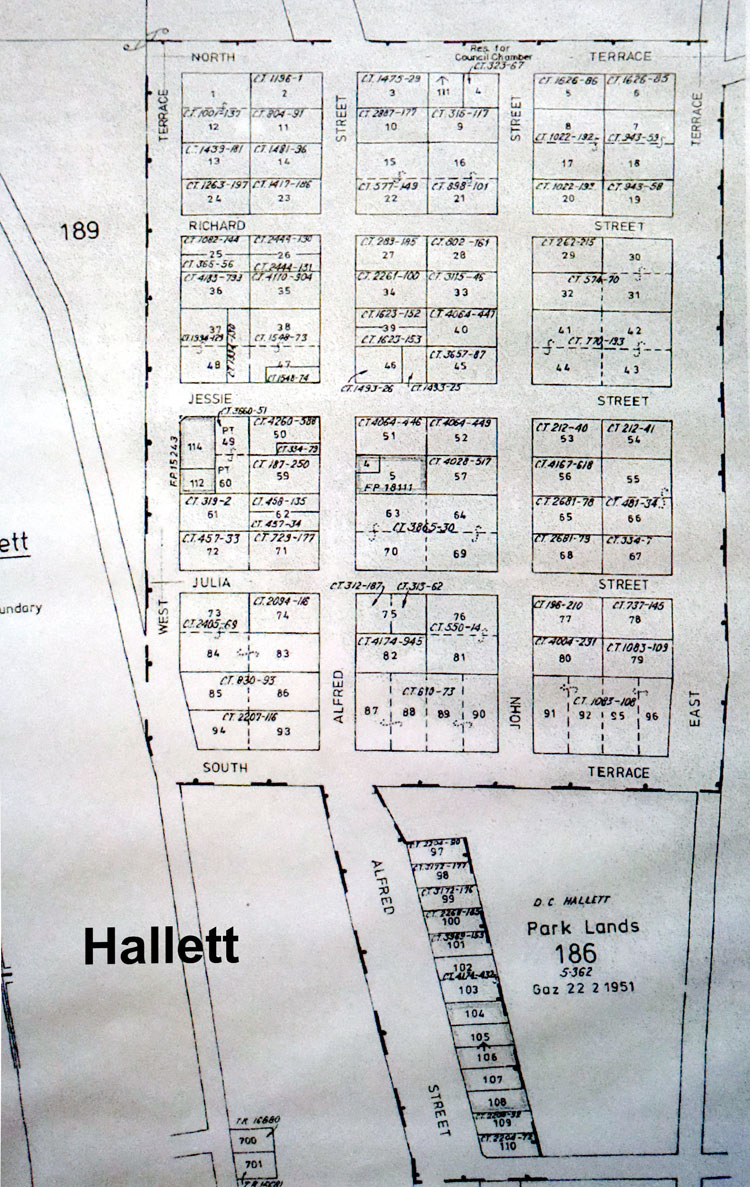
Hallett
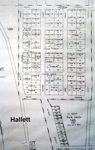
Detailed Survey map of Hallett
Courtesy: SA DPTI. Click here to enlarge

Detailed Survey map of Hallett
Courtesy: SA DPTI. Click here to enlarge
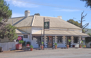
Hallett is a small town in the Mid North region of South Australia, situated on the Barrier Highway and former Peterborough railway line 32 kilometres north of Burra and 38 kilometres south-east of Jamestown, Hallett lies close to Goyder's Line, plotted in the nineteenth century by George Goyder, separating the land suitable for cropping from the land suitable for grazing. At the 2011 census, Hallett shared a population of 235 with adjoining localities.
The town of was named for pioneering pastoralist and politician John Hallett, and laid out on his property "Willogoleechee". The first allotments were offered for sale on 7 July 1870.

Hallett Original Institute

Methodist-Uniting Church (1880)
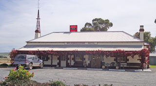
Wildongoleeche Hotel 2

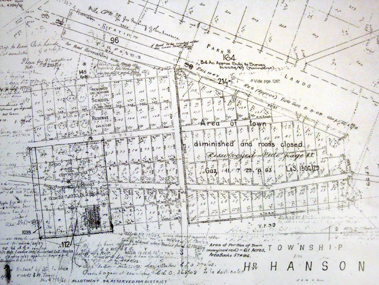
Hanson

Detailed Survey map of Hanson
Courtesy: SA DPTI. Click here to enlarge
Former Methodist Sunday School building, now used as a holiday home
Hanson (formerly Davies) is a town in South Australia located 29 kilometers north-east of Clare and 13 kilometers south-west of Burra at the intersection of the Barrier Highway and the Hanson-Farrell Flat Road in the Regional Council of Goyder. It is also adjacent to the former Peterborough railway line as the next station towards Adelaide from Burra which was the terminus for some time.
The town was surveyed in 1865 and originally known as Daviestown, Davieston, or Davies Town, named after Sir Richard Davies Hanson (1805-76), a Chief Justice of South Australia and acting Governor of the then colony from 1872 to 1873. A decision was made around 1890 to rename the town Hanson, although the name was not officially changed until 19 September 1940. The change brought the town's name into line with that of the nearby Hanson railway station. On the same date, the nearby town known as Hanson officially became Farrell Flat, also aligning that town's name with that of its railway station.
Over the years Hanson has comprised a church, a hall, a school, a shop, a railway station and a few houses

Hanson Church
Iron Mine

Former Primitive Methodist Church in 2004

Ironmine Church and Sunday School
Like Leighton this was a locality rather than a town and lies on the same road from Burra.
The name is descriptive and it was the site of a mine for ironstone to be used as a smelting flux.
Adjacent to the mine site there was a Primitive Methodist Church and tennis courts. Not far away was a blacksmith.
Today the church is a private home.

Ironmine Tennis courts

Ironmine blacksmith's corner
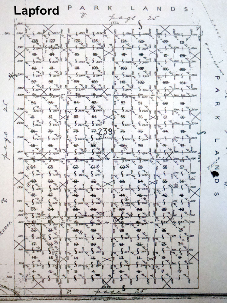
Lapford

Detailed Survey map of Lapford
Courtesy: SA DPTI. Click here to enlarge

Detailed Survey map of Lapford
Courtesy: SA DPTI. Click here to enlarge

This paddock (shown here in January 2001) was the centre of the town of Lapford

Lapford lay to the left of the road and the trees are along Burra Creek at World's End Gorge
This town was in the Hundred of Bright, and was located 16 km north of Robertstown on the north bank of the Burra Creek at a place better known as World’s End Gorge. It was proclaimed on 9 August 1877. It has a namesake in Devonshire, England, with which Governor Jervois, who named it, had family associations. In the Domesday Book the English Lapford is written as eslapaforda, meaning ‘Hlappa’s ford’. The SA version ceased to exist on 13 December 1962.
It was offered for sale on 13 September 1877. There was a school reserve which was never used.
Today it is farmland.
The only precise suggestion of housing comes from this report:
Burra Record, VI, 418, 27 February 1885, Page 3
Lapford Correspondent.
[There were correspondents’ reports from many centres on a fairly regular basis, but since nothing much ever happened at Lapford the correspondent purporting to give news from there often produced a humorous article sometimes with wider ranging satirical comments.]
‘Were one seeking the hospitality of Lapford, he would fare very badly indeed; for there are only two houses and three inhabitants all told, in the entire township proper; and “entertainment for man and beast,” is but a dim and misty legend of bygone days.’
‘The survey “pegs” are here, and the streets, roads, and “blocks” are here, but all is desolation beside.’
An effort was recently made to open a school here. The school is held in an iron building once devoted to the dispensation of Wein und Läerbier.
[But the school was in a building that lay outside the town proper and closer to the World’s End Methodist Church which was nearby and eventually housed the World’s End School as well.]

Leighton

Leighton School 1986

Leighton School House 2013
This is not a town, but a locality with a cluster of functions.
The post office opened in 1877 officially as Leighton (Baldry), though Baldry was some 6 km west.
There was a school from 1880 and later a District Hall and sports grounds including a polo ground, and provision for bowls, croquet and tennis.
The Leighton Wesleyan Church was further towards Baldry as were the sporting facilities, but the Hall and School were together.

Leighton Hall before demolition in 2003
Mongolata

Mongolata Mine - Nov 1933

Mongolata Mine - the Main Drive

Mongolata Mine - timbering in one of the drives

Bill Carpenter's Eating and Boarding House, Mongolata. The business ran for nine years - the lifetime of the gold mine
The Hundred was proclaimed on 30 December 1875.
The word "Mongolata" is Aboriginal of unknown meaning.
There is no town of this name but a school near the abandoned town of Tracy operated (1893-1899).
The locality came to prominence with the development of a goldfield there in the 1930s. This saw the establishment of a transient village with as many as 100 people at times.
There was an eating house and a Government Battery but while a couple of the larger companies made money most prospectors struggled to make wages.
Data from the Mongolata Mine can be found here

Mongolata 1991

Mongolata 1930s ruins looking to ridge scarred by workings. 1996

Mongolata School

Shelter at Mongolata 1931

Mt Bryan

Detailed Survey map of Mount Bryan
Courtesy: SA DPTI. Click here to enlarge

Detailed Survey map of Mount Bryan
Courtesy: SA DPTI. Click here to enlarge
St Brendan's Catholic Church
This was a private town 16 km north of Burra, laid out by Alfred France in May 1878. The name comes from Henry Bryan, a member of governor Gawler’s exploration party, who was lost in the bush on 15 December 1839. It is in the Hundred of Kingston on part section 75.
It was located to take advantage of the railway then being extended to Hallett. On 30 May 1907 a Government town was added to it and named Mt Bryan East. This led to confusion with the Mt Bryan East that already had a school and church. On 20 February 1941 the Government town became Mt Bryan officially.
The town prospered in the late nineteenth and early twentieth centuries with shops, a hotel, school, an Institute and churches for the Anglicans, Methodists and Catholics, as well as having a railway station with passenger and goods function. Apart from the hotel it is now essentially a small residential cluster.
The Mt Bryan District Council building predated the town and was a couple of kilometres north of it. It is now a heap of rubble, as shown in this March 2001 photo
Soldiers' Memorial Hall
Mt Bryan Hotel


Sod Hut

The ruins of the Sod Hut Inn. Photo: Jan 24, 2000
This was not a town, but was the site of a hotel called the Sod Hut Inn on section 21 Hundred of Kooringa. The site was leased by Daniel O’Leary from G.S. Kingston in the 1840s and he purchased the freehold in 1852. Though it may have started out as a descriptive name, the hotel was eventually quite a substantial stone building and was still standing and roofed, though unoccupied, in the first decade of the twentieth century. The proprietors of the inn were:
Daniel O’Leary 1850-1865
T. Hare 1866-1875
John Fradd 1876-1883
Spring Bank
In this March 2001 photograph the site of the chapel can be identified from the remaining stones scattered here and the slight depression with a slightly greener tinge in the centre of the photo
This locality is a valley and farming community along a valley that runs south from Burra a little to the west, roughly in line with Copperhouse etc.
The only services in the area were a Primitive Methodist Chapel (Section 2222) and some tennis courts.
The name is used in England, but whether this is the origin is unknown.
Tracy

Detailed Survey map of Tracy
Courtesy: SA DPTI. Click here to enlarge

Detailed Survey map of Tracy
Courtesy: SA DPTI. Click here to enlarge
Governor Jervois probably honoured a friend or acquaintance by naming this town in the Hundred of Mongolata. It lies 18 km northeast of Burra and was proclaimed on 8 September 1881.
It was offered for sale on 13 October 1881. There is an unused school reserve and an unused cemetery. There was consideration of closing it in 1959, but no action was then taken.
There does not ever seem to have been any building at the site.

Detailed Survey map of Tracy
Courtesy: SA DPTI. Click here to enlarge


Warrapoota
In the Adelaide paper the Register, 2 August 1858 we read:
‘The township of Warrapoota was offered for sale at the Burra Hotel on Thursday in blocks of one, two, three and five acres, but there were no purchasers. It was again offered on Saturday with the like result. This is rather disheartening to those who are at present offering their land for sale in this manner, there being a considerable quantity in the market at present, viz. Millerton, Clonmel, Copperhouse, Hampton, Roachtown, Nelson, Yarwood and Warrapoota, besides Redruth Aberdeen and Kooringa.’
Apart from the odd mention of its name in lists of subdivisions, probably all based on this paragraph, there is no other evidence known about Warrapoota.